Today we travel Westwards through the farm areas sandwiched betwwen the desolate highlands and the sea. There seems to be a lot of hay being harvested but not much livestock - perhaps the animals are kept inside all year but we do see occassional fields with a few sheep, cows or horses : but no pigs ! We were told of one farm that used to run 1,000 sheep but it had now been decreed that it could only have 300. Aparantly, Island produces enough meat for home consumption but is no longer competitive in the world market. You would think that, with its unique origins, a niche market could be found.
 |
| Möðrudalur |
From the carpark we walked through some rough ground until we crested a rise and looked down into the valley - it was a truely spectacular sight : the deep roar of the water, the spray/rainbows, the biblical flow of water and the ant-sized people totally dwarfed by its scale. It was a unique place to sit and have a picnic - only slightly deminished by what I thought was pate with orange being, in fact, orange soft cheese. It wasn't that bad and it, with some bread, soon disappeared.
Just down the road we walked up to the "new" lava at Krafla/Leirhnjúkur where the last eruption was in only 1975 - a nono-second ago in terms of geology. The ground was black and slag-like with bubbling steaming pits (no lava unfortunately) and steam issuing from the rocks we skirted. You could see where lava had flowed down and around - leaving vestigal green islands in the stygian landscape. Back at the carpark, with a few minutes to spare, I sampled one of Island's delacies : a hot dog - not too bad !
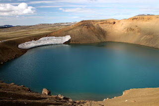
Just down the road we climbed up and looked down into a blue lake of the Viti Crater still with a crecent of snow on its edge. It is about 500ft. in diameter and almost 200 ft. from the rim down to the water at the bottom of the crater - the water itself is around 26 ft. deep. It was formed in 1875 by a violent eruption in the Dyngjufjoll Mountains
All around were little geodesic domes cover the well-heads and insulated pipes supplying superheated water to the Krafla geo-thermal powerstation.
 |
| Námafjall |
Our final journey today was along the shores of Lake Mývatn and to our hotel - the Fossholl which overlooked the famous Goðafoss (waterfall of the gods) The water of the river Skjálfandafljót falls from a height of 12 meters over a width of 30 meters.
 |
| Goðafoss |


No comments:
Post a Comment